Features
Laser mapping is characterized e.g. by:
- Resistance to adverse meteorological conditions
- Capability to penetrate vegetation
- First and last pulse discrimination
Meteorological conditions
Generally speaking, laser mapping can be performed in all seasons and at any time during the day or night, provided that there are no obstacles (such as clouds, rain or ground mist) between the aircraft and the surface to be mapped. Since in most cases mapping focuses on the ground surface, November to April will be the preferred months because of their favorable vegetation conditions (no/little foliage or ground vegetation).
Penetration
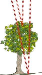
A laser pulse that is fired over vegetation can produce multiple reflections, since some particles of the light pulse are reflected by the vegetation in different places, whereas others penetrate to the ground. The last measured reflection is most likely to be a ground point, whereas the first reflection is often a vegetation point.
Multiple reflections
In addition to the first pulse and the last pulse, the new mapping systems (ALTM 3100 and better) can record up to four reflections (multi-pulse method). The method to be used is chosen to suit the specific application; for topographic elevation models, for instance, the last pulse method is normally preferred.
